

Dear Summer Solstice Tour Participant,
Thanks again for signing up for the Bicycle Club of Irvine's Summer
Solstice Tour!
I trust you will not share this secret info to any one who is
not signed up!
This is detailed route information...
Maps & Pictures,
I will hand out & go over the actual
route sheets Saturday.
PLEASE WAIT UNTIL 9AM TO LEAVE!
Some folks are fine
with the route
sheet I will give you
Saturday
~ other's really like MAPS!
Here is the route; detailed with maps.
If you want maps - please print out your own copy of this web
page...
It may take a while
to download this site - and about 14 pages to print it all,
but if you study it you will see how easy the route is
& will not even need a
route sheet this weekend!
Remember - the ride meets @ 8:30 & leaves @ 9AM from DCP in
Irvine
along with the regular Saturday Club Riders
We will start from Deerfield Park because the Civic
Center is hosting a huge festal on the 21st.
Please park your cars on the streets as usual for Deerfield, leaving
the parking lot free for park guests.
The Parking lot exits on DEERWOOD; briefly - just
to get out to the left on IRVINE CENTER DRIVE East to ALTON
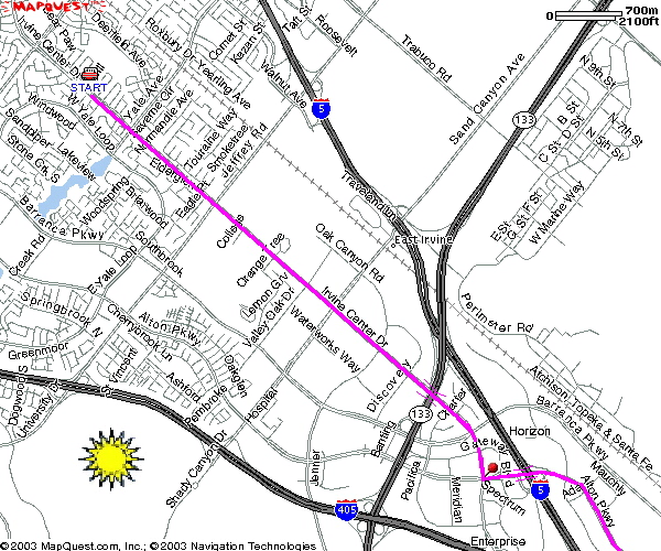
We will head down ALTON to BARRANCA / MUIRLANDS
- still in familiar territory!
MUIRLANDS all the way till it ends at LA PAZ - then
a jog under the Freeway on LA PAZ to CABOT:
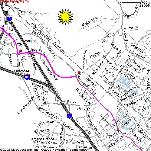
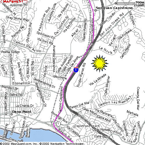
CABOT gets ugly by the Crown Valley CostCO: Hilly &
no bike lane...
but there is the OSO CREEK BIKE TRAIL (dotted line
on map) that gets you over to FORBES ROAD.
FORBES ROAD goes right into the MetroLink depot where
you can get under the railroad tracks !
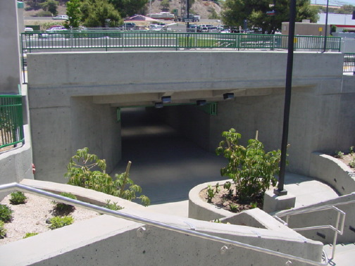
Laguna Niguel / Mission Viejo MetroLink Depot:
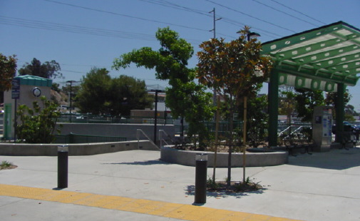
RR Xing Underpass:
 24 steps down - Forbes Side:
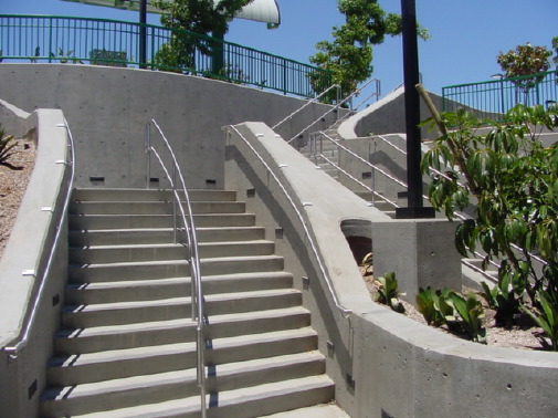
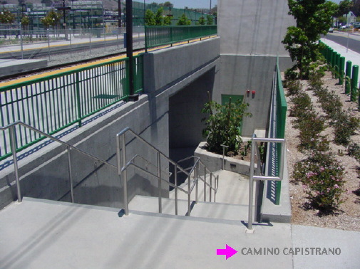
24 steps up - Camino Capistrano side:
and if you are loaded there are even a pair of elevators ~ one
on each side!
The underpass gets you out to CAMINO CAPISTRANO. No fording
creeks, mud or sand !
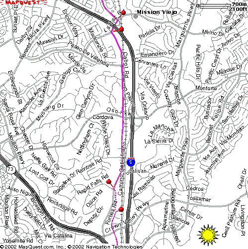
We take CAMINO CAPISTRANO all the way down hill past the
mission right to the beach...
Or if you prefer BIKE TRAILS pick up the Trabuco Creek
BIKE TRAIL to the San Juan Creek BIKE TRAIL
all the way to the shore of the Pacific...
See the Sunday return details below for BIKE TRAIL option...
CAMINO CAPISTRANO is a frontage road to the 5 freeway after
crossing San Juan Creek, then it drops down into Capistrano Beach,
and at the beach it flows right into the COAST HIGHWAY
and EL CAMINO REAL; Stay on it all the way through San
Clemente;
There is a popular Carl's JR where folks stop as a last chance
for cold drinks & lunch before San Diego County;
but there are much better choices for lunch earlier in San Clemente...
At the end of EL CAMINO REAL turn right on CHRISTIANITOS
over the Freeway.
Just behind the fence at the on ramp, there is a BIKE TRAIL /
SURFER FOOT PATH down to the old highway bridge.
The trail connects to the old highway frontage road past San Onofre
Power Plant and into San Onofre State Beach campground.
Ride all the way through the camp site & out the South end
gate into Camp Pendleton...
The old highway continues to run from the South end of San Onofre
State Beach campground
all the way to LAS PULGAS as a Bike / Tank lane;
Since Camp Pendleton is still on alert, we will not be allowed
to ride the base past LAS PULGAS again this year.
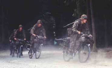
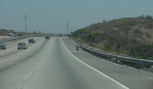
WE WILL BE RIDING ABOUT 8 MILES ON THE FREEWAY!
SEE
Charlie & Lynne's OCW AMTRACK CENTURY page with details &
views of this part of the route!
We will have Bob Nugent's aid station at LAS PULGAS;
Look for him in the shade under the 5 Freeway
Regroup here & ride the I-5 Freeway South together
in SINGLE FILE packs: A group is more visible!
Stay Right & SHOUT OUT if Passing other riders on their left;
it get's loud on Freeways!
Yes it's legal; and the shoulder here is wide and pretty smooth:
But keep alert, to the right & single file!
You MUST exit at the rest stop (2 miles) so regroup there again
for the next 6 miles...
AGAIN:Remember to ride to the RIGHT edge &
call out "ON YOUR LEFT" when you choose to pass someone.
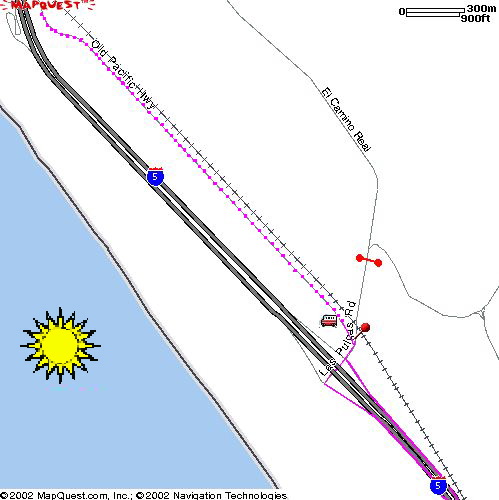
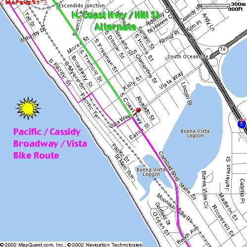
You will get off the Freeway at OCEANSIDE HARBOR DRIVE;
If you want to do HELL (I mean HILL) STREET Saturday go
straight off the Freeway up past the Denny's;
HILL continues all the way to camp but it is down-town
Oceanside & ugly riding; (green line)
Best to drop down to the Marina on HARBOR & get onto
PACIFIC; It follows the beach;
slower going but scenic and much nicer! (pink line)
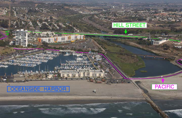
At the South end of Oceanside the Bike Route turns off PACIFIC
at CASSIDY, jogs on BROADWAY & VISTA,
Then turns onto HILL STREET / COAST HIGHWAY / CARLSBAD BLVD
into Carlsbad and on to camp
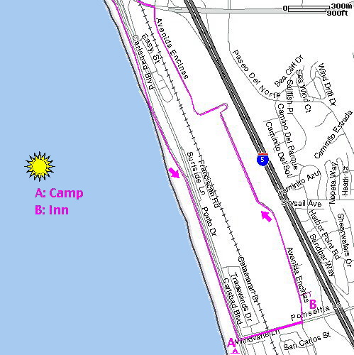
CARLSBAD BLVD follows the shore; at POINSETTIA Turn
into camp (A) if you are camping; (Sites126 & 175)
or turn Left on POINSETTIA to AVE ENCINAS;
The Inns of America is on the corner (B). Motel 6 is right across
from the Inn...
In the evening we will all walk over for Dinner & to watch
the sun set & roast marshmallows at the Group Campfire (A)
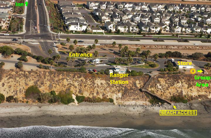
Group
area inside the State Beach Campground
SUNDAY RETURN
In the Morning, the campers ride to the Inn to get
some coffee & say good morning;
Every one trickles out so check out early if you want to group
up!
AVENIDA ENCINAS takes you North from the Inn to PALOMAR
AIRPORT ROAD;
which drops you over the track onto NORTH PCH/ COAST HIGHWAY
/ CARLSBAD BLVD / HILL STREET
Breakfasts along the road into Carlsbad & Oceanside if the
continental breakfast is not sufficient;
You can jog over with VISTA / BROADWAY / CASSIDY to PACIFIC
back to HARBOR but the hill out of the marina is a huff!
Sunday Morning if it's foggy the beach is not as nice, and HILL
STREET is quieter, and offers breakfast stops
so you may choose to stay on it coming North... You eventually
need to get to HARBOR.
You go under the I-5 Freeway on HARBOR; Cars are
merging in & passing the right, at FREEWAY SPEEDS
but as you approach the main gate to Camp Pendleton you should
hold your lane & make the first left turn pocket (SAN RAFAEL)
onto the I -5 FREEWAY; Regroup with a few others; more
riders are more visible and wear your brightest gear!
You can regroup again about 6 miles North at the rest area. Watch
the mirrors & hope the fog lifts!
After about 8 miles on the I-5 Freeway, Las
Pulgas get's you back to the quiet Bike Trail to San
Onofre State Beach...
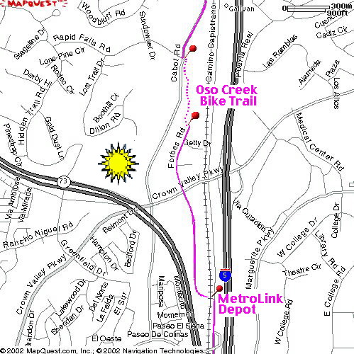
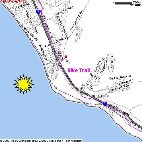
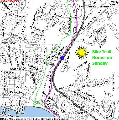
After San Clemente, we will be taking the Bike Trail
from Capo Beach upstream through San Juan Capistrano
So other than this Bike Trail portion, we follow the same
route home all the way back to Irvine...
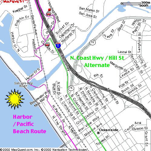
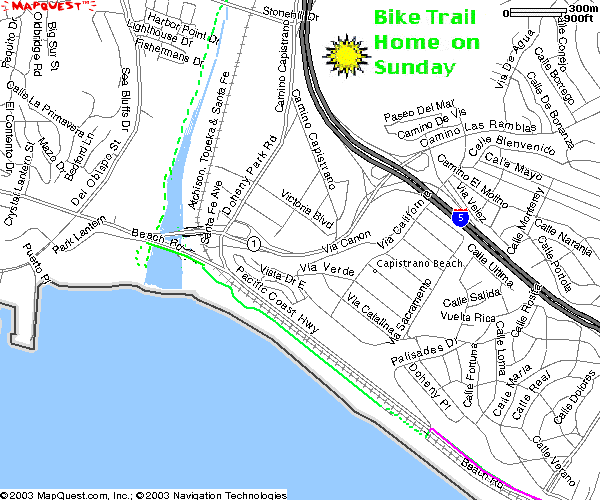
BIKE TRAIL DETAILS: CAPISTRANO BEACH to SAN
JUAN CAPISTRANO:
Pink route is Saturday Southbound; Green is Sunday's Bike Trail
Home:
The COAST HIGHWAY follows the shore from San
Clemente to Capistrano Beach; at PALISADES turn left toward
the sand;
Just over the rail road tracks a BIKE TRAIL follows the
old BEACH ROAD into Doheny State Beach.
A BIKE TRAIL follows San Juan Creek up into San Juan Capistrano.
Much nicer than staying on Camino Capistrano Northbound, which
has no shoulder where it runs along the freeway.
The San Juan Creek BIKE TRAIL follows the channel to Descanso
Park. There we turn up stream on Trabuco Creek BIKE TRAIL
The Trabuco Creek BIKE TRAIL ends at AVENITA DE LA VISTA.
Turn right on LA ZANJA which crosses the rail road tracks;
Turn left back onto CAMINO CAPISTRANO.

If you want to stop near the mission, you can explore the historic
old 'Los Rios' area, by taking RAMOS to LOS RIOS;
you can walk across the tracks at VERDUGO to get over toward
the mission, and then resume the tour on CAMINO CAPISTRANO
Northbound.

