Camino Capistrano in San Juan Capistrano
Before the Interstate Freeway 5 came through Orange County, Highway 101 was a 2 lane concrete ribbon.
Camino Capistrano is the old Highway 101 and has concrete pavement
north of Junipero Serra Rd that dates from the 1930's & 40's.
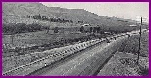
Hwy 101 along RR Tracks in San Juan Capistrano in the 1940's
The route is a favorite for active transportation and recreational
cycling, as it connects down town San Juan Capistrano to the Laguna
Niguel / Mission Viejo station.
Unfortunately, not much has been done to maintain the road since the
1960's when the Freeway was constructed along it's east side.
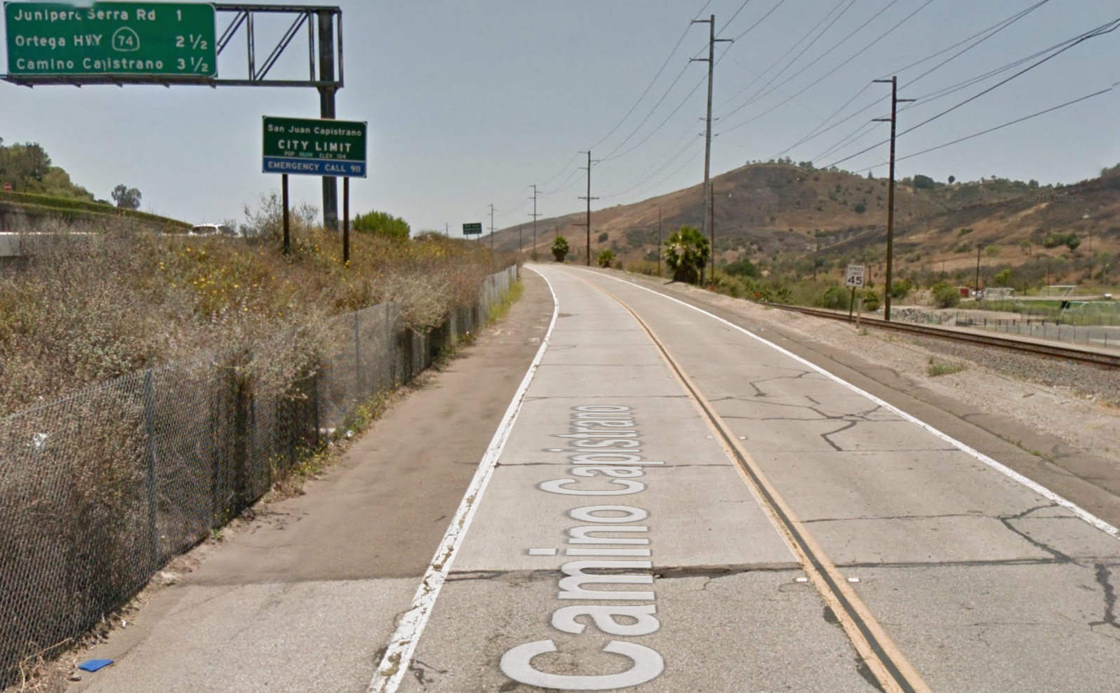
The old asphalt shoulders along the edges of the two lane concrete highway are much as they were -
the speed limit has been lowered to 45 MPH, and the shoulders have been
painted as Class II Bike Lanes, but are substandard and pavement
conditions make the ride very rough.
The edge stripe between the travel lanes and shoulder have been widened
and the standard Bike Lane stencil has been painted,
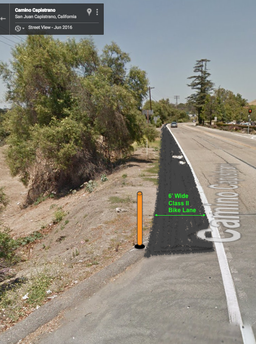
but as the speed
limit is over 40 MPH, the minimum mandatory width under California
Highway Design standards is 6 feet.
The Bike Lane does not have any "Bike Lane" signs, just the standard
stencils and wider white lane line to designate it as a mandatory use
Bike Lane.
All of it is over due for a pavement improvement. The asphalt patch
work and cracks of the Bike Lanes and Travel Lanes are significant all
the way to the City Limit.
The south bound edge is scattered with
gravel, the north bound skirts a fence line with over grown weeds right
at face height of cyclists:
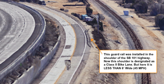
At at least 2 major points the Bike Lane is much to narrow.
ONE is on the South Bound side - where the drop off on the curve
required a guard rail be installed along the edge to reduce the chance
of a motorist swerving off the cliff and landing on the rail road
tracks below.
Since their was no attempt to provide a retaining wall on the
cliff, the wooden posts for the rail were planted IN the paved
shoulder, and with the steel rail on the highway side, had narrowed the
shoulder at this curve.
Now that this shoulder is being "called" a Bike Lane, it is way less
than 6 feet wide on a curve where cyclists are most vulnerable to a
passing motorist drifting into the bike lane.
The fix would be expensive, the embankment would need to be stabilized
and supported with a verticle wall, to put the rail farther from
the travel lane - allowing 6 feet or more for teh Bike Lane.
The curve could be even safer for cyclists if the Class II Bike Lane
became - briefly - a one way Class IV Protected Bikeway, with a
concrete barricade between the travel lane and cyclists.
Of course that would require a 3 foot shoulder between teh travel lane
and barrier - a couple of feet for the concrete rail, at least 3 feet
of asphalt for bikes + 2' gutter pan & curb, then a shoulder or
side walk for pedestrians to walk along, and a fence to keep them from
falling off the edge.
Looking south bound: I-5 Freeway above - Camino Capistrano center - Rail Road below.
At some time the south bound concrete lane must have been sliding off the
cliff and it was patched with asphalt lane & new rail on narrow shoulder.
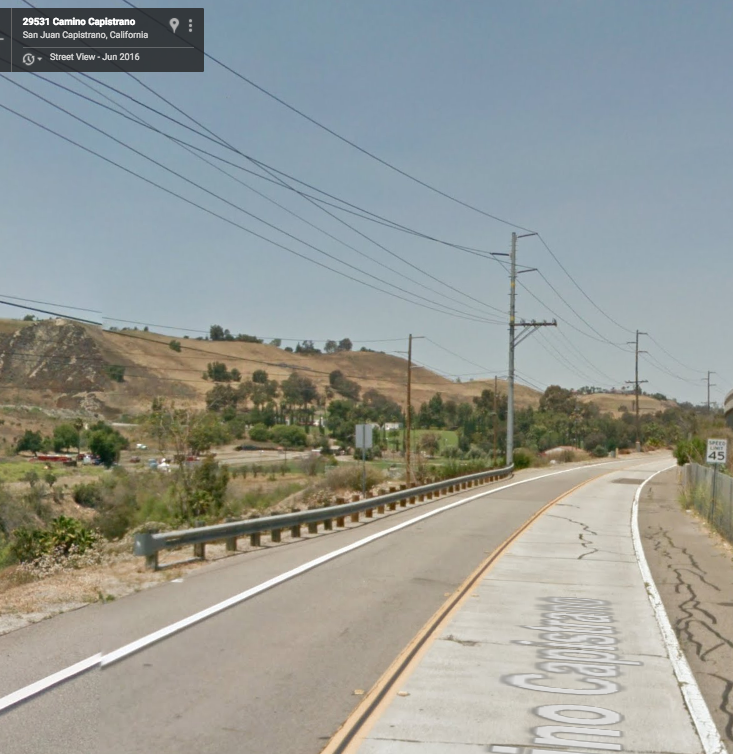
Looking north bound: Railing on curve narrows cyclists even closer to south bound travel lane.
Notice posted speed limit and condition of north bound shoulder right along fence of I-5 Freeway.
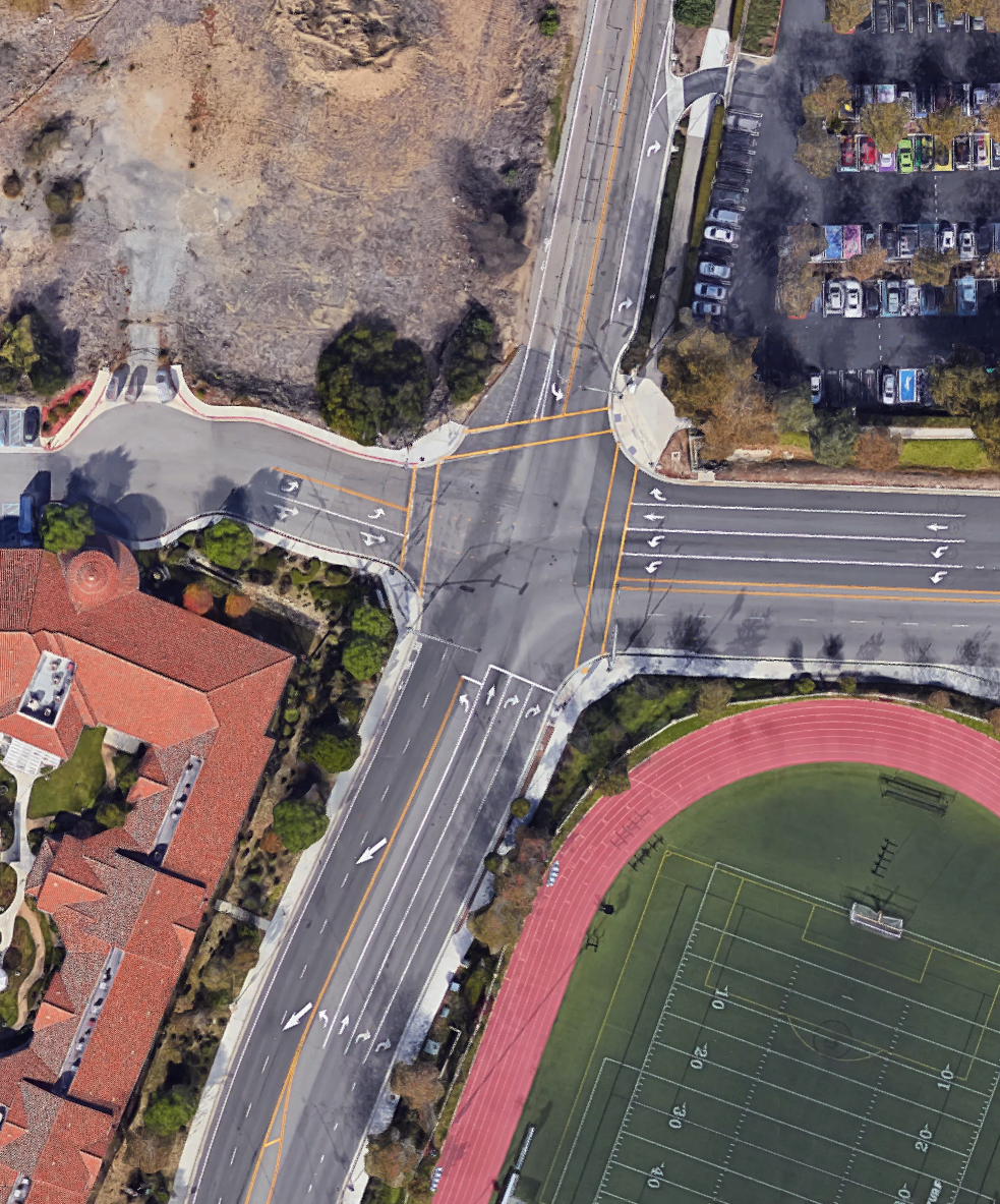
SECOND is where the City approved development on the NE corner of
Camino Capistrano and Junipero Serra Rd, but did not do anything to
expand the road on the NW corner.
As a result, the very nice Class II Bike Lanes on NB Camino Capistrano
just disappear with double right turn lanes to Junipero Serra Rd, and
after teh intersections, there are a series of right turn only lanes
with no Bike Lane at all until the old shoulder resumes north of the
new development.
This north bound stretch has no BIKE ROUTE signs, Has NO BMUFL signs,
no sharrows, and has no facilitated Bike Lane treatment to the left of
the two right turn lanes. This leaves cyclists to merge across to the
trough lane and be followed by motorist expecting to go 45 MPH or
more, or to illegally proceed straight on the edge of double right turn
lanes, risking being overtaken and right hooked by motorists legally
turning right on the green signal, or to get off their bicycle &
use the side walk & cross walk for the entire stretch.
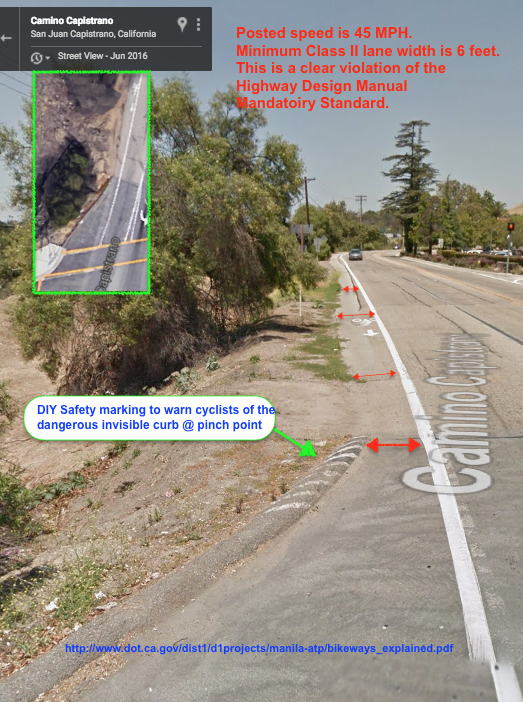
On the south bound side, since the center line was placed with room fro
2 lanes of NB traffic and turn lanes, the Bike LAne is wedged down to
a narrowing width way less than 6 feet wide, into a pinch
point where the City actually placed a rounded asphalt curb into the
Bike Lane. Being the same color as teh bike lane, this hazard is so
obvious, that local cyclists have painted diagonal stripes on that curb
just to make it visible to cyclists who should be paying attention to
street signals and vehicles that may be using the bike lane to turn
right at Junipero Serra Rd.
The Temporary & immediate "Fix" here is to widen the road on the
west side of Camino Capistrano to provide a 6' Bike Lane all the way to
Junipero Serra Rd.
That probably should have been conditioned on the developer who
profited on building the NE corner and should not be delayed until a
developer profits on building out the NW corner.
The long term "Fix" here - is to complete the widening of Camino
Capistrano on the NW corner and to extend the Class II Bike Lanes on
Camino Capistrano:
That includes guiding the bike lane users left of the double right turn
lanes at Junipero Serra Rd to the left of teh right turn only lanes.
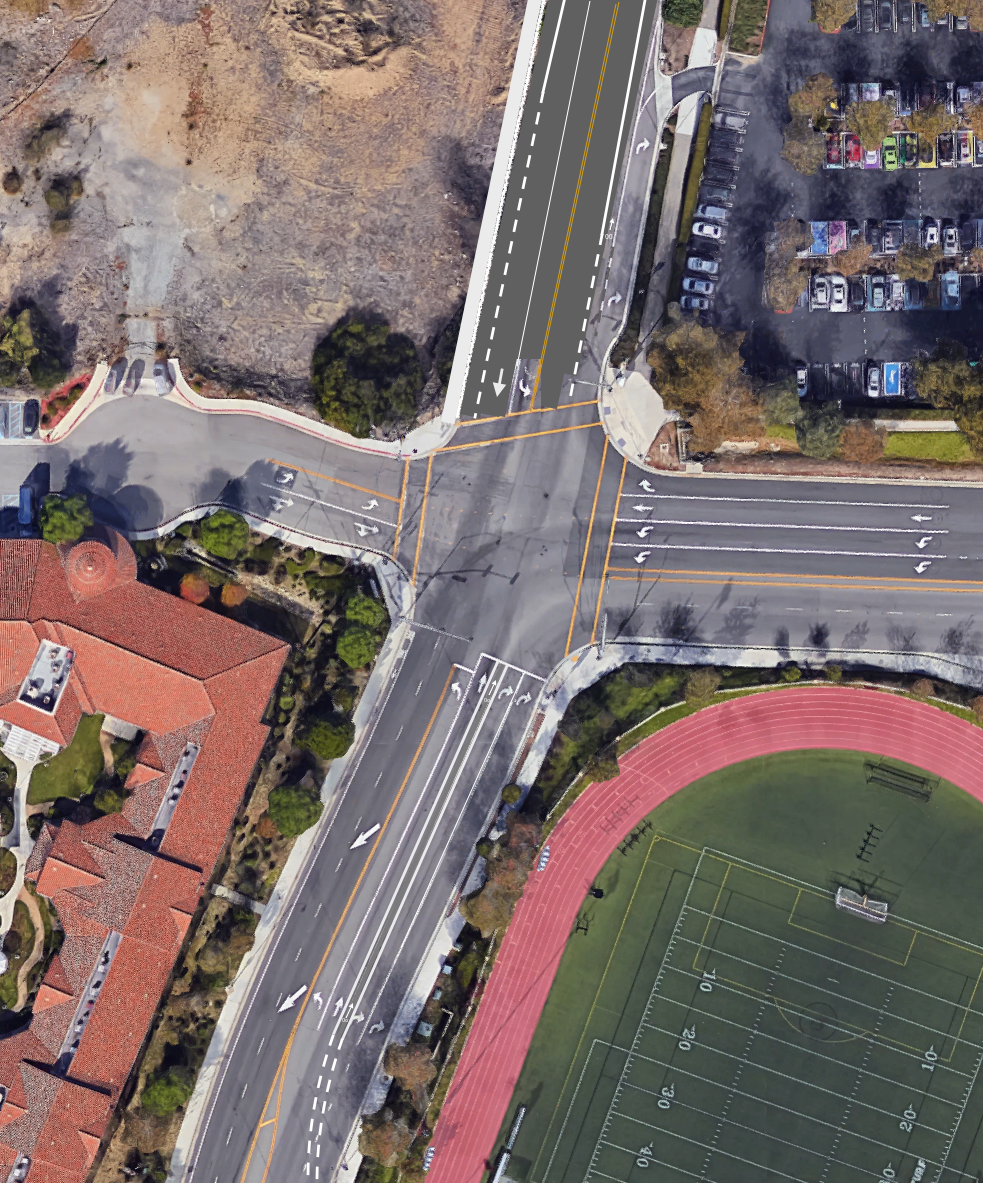
Compared to current conditions: No NB Bike Lane, Pinched SB Bike Lane.
NB Bike Lane vanishes before intersection and traps edge riders on right of two right turn only lanes.